Weather
Tropical Disturbance Edges Closer to Florida; Gaston Weakens for Now
Breaking: The National Hurricane Center is tracking three storm systems in the Atlantic and Gulf of Mexico.


TAMPA BAY, FL — While Tropical Storm Gaston continues on a path near Bermuda, residents throughout Florida and the Tampa Bay area are keeping an eye on a disturbance now located between the Bahamas and Cuba.
And if those two storms weren’t enough to keep weather watchers busy, another disturbance cropped up overnight in the Gulf of Mexico. That storm is expected to steer clear of Florida, but it could have a run-in with Texas before the weekend is out.
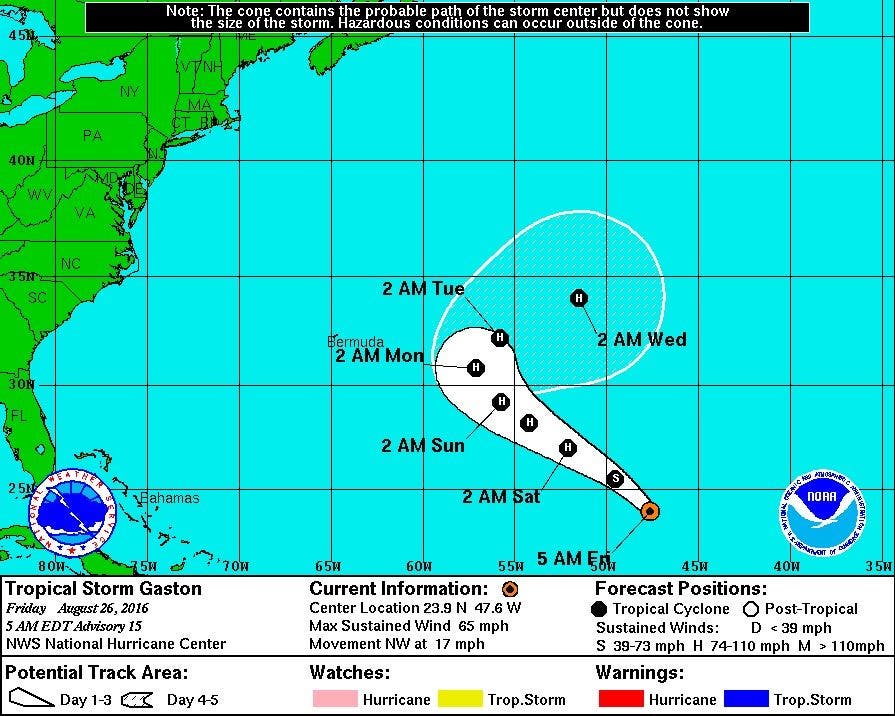
As of Friday morning, Tropical Storm Gaston was located about 980 nautical miles east-northwest of the Leeward Islands, according to the National Hurricane Center. Packing maximum sustained winds of 65 mph, the storm has weakened somewhat since it was downgraded from a hurricane back to a tropical storm Thursday.
Find out what's happening in Clearwaterfor free with the latest updates from Patch.
Tropical Storm Gaston is moving northwest at 17 mph. Forecasters anticipate the storm will regain hurricane status sometime on Saturday and remain strong until passing east of Bermuda sometime between Monday and Tuesday.
The disturbance that has Florida’s attention was located between the southeastern Bahamas and the northeastern coast of Cuba Friday morning. The broad area of low pressure is associated with a tropical wave. At present, the storm is kicking up disorganized showers and thunderstorms, the hurricane center reported Friday morning.
Find out what's happening in Clearwaterfor free with the latest updates from Patch.
The storm is not expected to strengthen much over the next day or so, but forecasters say “environmental conditions could become a little more conducive for development over the weekend or early next week while the system moves through the Straits of Florida and into the eastern Gulf of Mexico.”
Should it develop enough to earn a name, it will be called Hermine, the eighth named storm of the 2016 Atlantic Hurricane Season.
Forecasters have given the system a 30 percent chance of further development over the next two days. It has a 60 percent chance of developing more over the next five days. As of Friday morning, it was moving west-northwest at 10 mph.
As for that third system now under watch, forecasters describe it as an “area of disturbed weather.” It was located over the northern portion of the Gulf Friday morning. Forecasters have given it only a 10 percent chance of developing more before it arrives on the coast of Texas over the weekend.
As hurricane season’s peak continues, emergency management officials urge residents throughout Tampa Bay to be prepared.
To find out more about hurricane season and storm preparation, read these related Patch stories:
- Hurricane Season 2016: Where To Find Local Information
- 2016 Atlantic Hurricane Season Forecast Released
- Hurricane Season: How to Prepare
- 2016 Hurricane Names: Is Yours On the List?
- Tampa Bay 'Ripe for Disaster,' Hurricane Experts Say
To keep up with storm activity as the season develops, bookmark the National Hurricane Center’s website and keep an eye on your hometown Patch site for local information.
Images courtesy of the National Hurricane Center
Get more local news delivered straight to your inbox. Sign up for free Patch newsletters and alerts.