Weather
NOAA: Cold, Snowy La Niña Winter Will Hit Parts Of WI Hard
The National Weather Service expects a colder, wetter winter to persist into spring 2026 under a weak La Niña pattern.


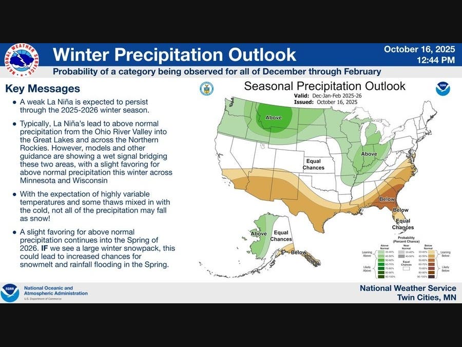
WISCONSIN — The National Weather Service says some Wisconsinites should brace for a colder, snowier winter this year, with a weak La Niña expected to persist through the 2025–2026 season.
“These La Niña conditions, along with other favorable forcing mechanisms, favor below normal temperatures for Minnesota and northwest Wisconsin during the winter season,” the National Weather Service said.
The agency said a “gradual descent into winter is probable, with the greatest chances for below-normal temperatures mid-winter (January and February).”
Find out what's happening in Milwaukeefor free with the latest updates from Patch.
Meteorologists also expect “highly variable conditions” with some thaws interrupting cold snaps, though the overall three-month trend is expected to skew colder.
On the precipitation side, NOAA forecasters said “a weak signal bridging” the Ohio River Valley and the Northern Rockies is creating “a slight favoring for above normal precipitation this winter across Minnesota and Wisconsin.”
Find out what's happening in Milwaukeefor free with the latest updates from Patch.
Because temperatures are expected to fluctuate, “not all of the precipitation may fall as snow,” forecasters said. However, if a large snowpack develops, it “could lead to increased chances for snowmelt and rainfall flooding in the spring.”
The National Weather Service said the slight favoring for below-normal temperatures and above-normal precipitation is expected to continue into the spring of 2026.
Upcoming Milwaukee Forecast
According to the National Weather Service, the Milwaukee area will see a stretch of mild temperatures followed by several rounds of rain heading into the weekend:
- Thursday Night: A slight chance of showers between 7 p.m. and 9 p.m. Mostly cloudy, low around 56. Southeast wind around 10 mph. Chance of precipitation 20%.
- Friday: Mostly cloudy, high near 72. South wind 10 to 15 mph.
- Friday Night: Showers and thunderstorms likely, especially after 1 a.m. Mostly cloudy, low around 61. South wind 10 to 15 mph. Chance of precipitation 70%.
- Saturday: Showers likely and possibly a thunderstorm before 1 p.m., then showers likely through the afternoon. High near 70. Southwest wind around 10 mph. Chance of precipitation 70%.
- Saturday Night: Showers likely and possibly a thunderstorm. Mostly cloudy, low around 49. Southwest wind 5 to 10 mph becoming northwest after midnight. Chance of precipitation 70%.
- Sunday: A 40 percent chance of showers before 1 p.m. Mostly cloudy, then gradually becoming sunny. High near 59. Breezy, northwest wind 15 to 20 mph with gusts up to 30 mph.
- Sunday Night: Mostly clear, low around 45. West wind 5 to 15 mph.
- Monday: Sunny, high near 64. South wind 10 to 15 mph.
- Monday Night: A 40 percent chance of showers. Increasing clouds, low around 47.
- Tuesday: A 40 percent chance of showers. Partly sunny, high near 55. Breezy.
- Tuesday Night: A 20 percent chance of showers. Partly cloudy, low around 40.
- Wednesday: Mostly sunny, high near 55.
- Wednesday Night: A 20 percent chance of showers. Mostly cloudy, low around 44.
- Thursday: A 20 percent chance of showers. Partly sunny, high near 56.
Get more local news delivered straight to your inbox. Sign up for free Patch newsletters and alerts.


