Weather
City-By-City Snowfall Outlook: Updated Totals For Southeast Wisconsin
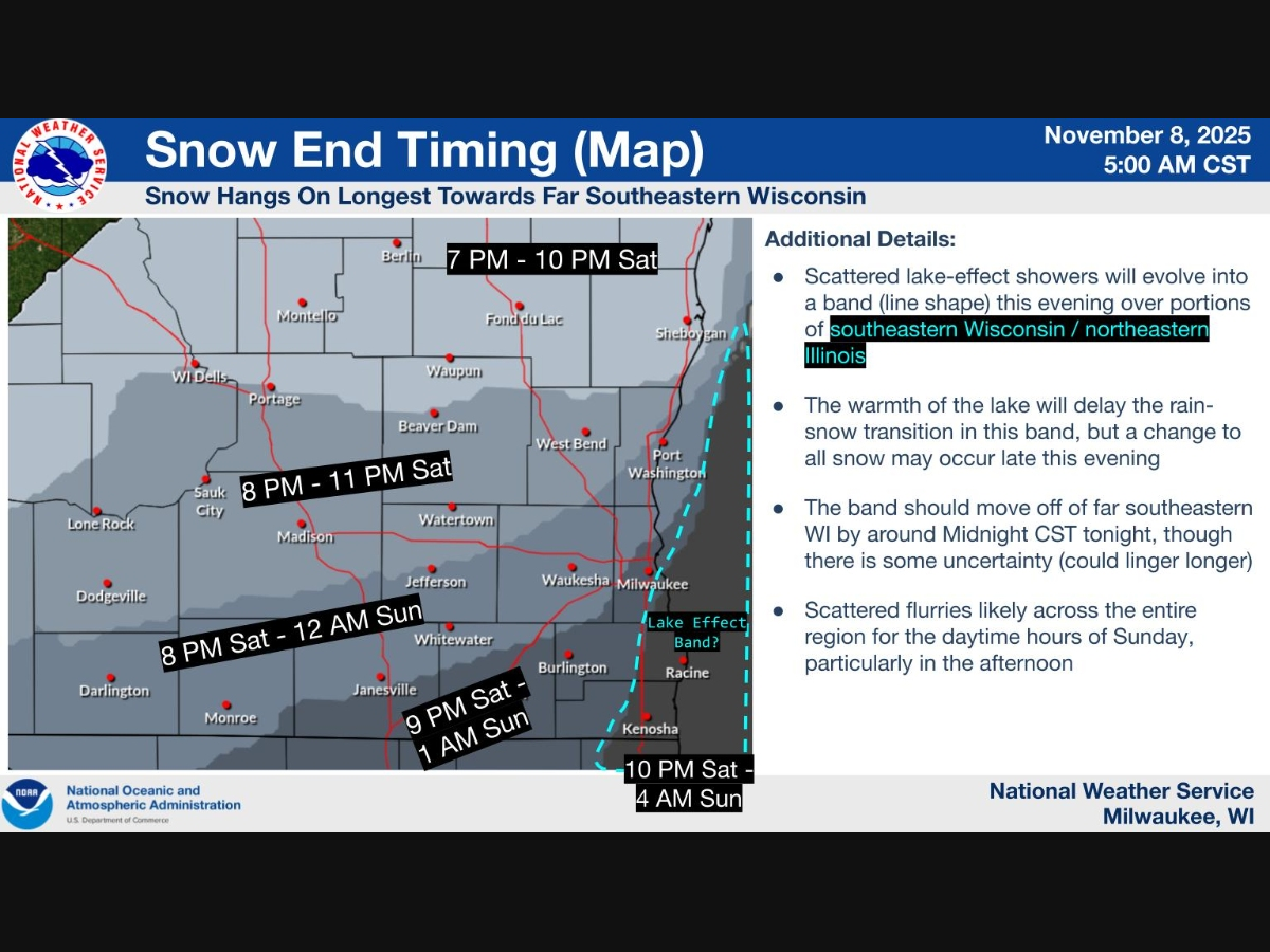
Rain will turn to snow Saturday night, with light accumulation expected inland and heavier totals possible near Lake Michigan.


MILWAUKEE, WI — The season’s first snow is on the way for southeastern Wisconsin, and the National Weather Service has updated its snowfall projections ahead of the system’s arrival.
Rain will move in Saturday afternoon before changing to snow later in the evening as temperatures dip below freezing. Forecasters say accumulation will be limited for most of the region, though some lakeshore areas could see more significant totals if lake-effect snow develops overnight.
For much of south-central and southeastern Wisconsin, snowfall amounts will range from just a few tenths of an inch to around 1 inch — mainly on grassy and elevated surfaces.
Find out what's happening in Milwaukeefor free with the latest updates from Patch.

Here’s the latest city-by-city forecast:
- Milwaukee: Around 1 inch possible; a slim chance of localized totals up to 3–5 inches near the lake.
- Racine: Expected around 4 inches, with a high-end possibility near 10–14 inches if lake-effect snow bands form.
- Kenosha: Around 3 inches expected; localized totals up to 12 inches possible in an extreme lake-effect scenario.
- Sheboygan: Expected 1 inch; high-end potential near 10 inches along the shoreline.
- Port Washington: Around 1 inch, with a 9-inch high-end scenario possible.
- Waukesha: Less than 1 inch expected.
- West Bend: Less than 1 inch, high-end potential up to 4 inches.
- Elkhorn and Burlington: Less than 1 inch expected, though Burlington could see higher totals if bands extend inland.
- Janesville, Madison, and Beaver Dam: Less than 1 inch expected.
The National Weather Service said any accumulation will likely remain on grassy or elevated surfaces due to warm ground temperatures. Roads may become slick in isolated spots overnight, especially on bridges and overpasses.
Find out what's happening in Milwaukeefor free with the latest updates from Patch.
Flurries could linger into Sunday afternoon, followed by the coldest air mass of the season so far. Highs will stay in the 30s Sunday and Monday before gradually warming into the upper 40s and low 50s by midweek.
Here's the full NWS forecast from the Milwaukee Airport:
This Afternoon: A 40 percent chance of rain. Cloudy, with a high near 42. Northeast wind around 10 mph.
Tonight: Rain and snow likely before 2am, then a chance of snow. Cloudy, with a low around 30. North wind 10 to 15 mph, with gusts as high as 30 mph. Chance of precipitation is 70%. New snow accumulation of less than a half inch possible.
Sunday: A slight chance of snow before 7am, then a chance of snow after 3pm. Partly sunny, with a high near 36. Breezy, with a northwest wind 15 to 20 mph, with gusts as high as 30 mph. Chance of precipitation is 30%.
Sunday Night: A 50 percent chance of snow. Mostly cloudy, with a low around 24. North wind around 15 mph, with gusts as high as 30 mph.
Monday: A 30 percent chance of snow, mainly before noon. Mostly sunny, with a high near 39. Northwest wind around 15 mph.
Monday Night: Partly cloudy, with a low around 25. West wind 10 to 15 mph.
Veterans Day: A 20 percent chance of snow before noon. Mostly cloudy, with a high near 43. Southwest wind 10 to 15 mph, with gusts as high as 25 mph.
Tuesday Night: Mostly cloudy, with a low around 35. West wind 10 to 15 mph.
Wednesday: Mostly sunny, with a high near 49.
Wednesday Night: Mostly clear, with a low around 33.
Thursday: Sunny, with a high near 50.
Thursday Night: Partly cloudy, with a low around 35.
Friday: Mostly sunny, with a high near 53.
Friday Night: Mostly cloudy, with a low around 41.
Saturday: A 20 percent chance of rain. Mostly cloudy, with a high near 60.
Get more local news delivered straight to your inbox. Sign up for free Patch newsletters and alerts.


